
Operations »Exploration » Manandaza – Block 3107
Block 3107 Manandaza
Block 3107 Manandaza:
Manandaza is just to the south of Tsimiroro (Block 3104) and is 6,580 square kilometers (1.6 million acres) in size. The seismic work in 2009 identified one large structure and three smaller structures in the 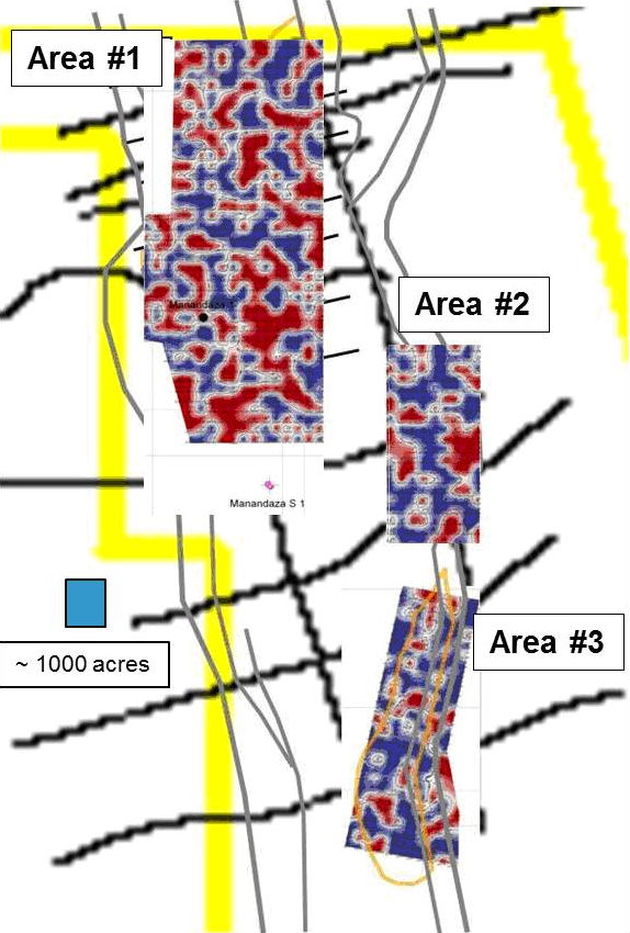 Lower Sakamena sandstone. There have been two prior wells in the block, one of which tested 41 degree API oil on drill stem test, but did not show sufficient potential to pursue further. The south end of the block has features that suggest that potential exists to justify future investigation, but no new work has been completed in that portion of the block.
The large structural closure and 3 leads mapped in the Lower Sakamena sandstone reservoir interval and are shown on the diagram and are as follows: Main Manandaza closure at approximately 14,000 acres; Area 2 at2,500 acres, and Area 3 at 3,000 acres.
The Manandaza #1 well tested 41° gravity API oil on a drill stem test in 1990; however, core results from the interval indicate a very low porosity (6%) and potentially a poor quality reservoir. The 2009 seismic also identified that the well intersected the zone at a fault which represents an additional uncertainty in the analysis.
The GORE micro seepage output has been overlaid on the prospect areas on the map below.
- Hydrocarbon Potential is indicated by red closures which represent a greater than 50% probability of subsurface trapped hydrocarbons.
- Good potential is indicated with above background readings noted in all three areas with the Main Manandaza (Area 1) almost saturated with hydrocarbon seepage and Area 2 with similar coverage. Area 3 has a lower density, but is still above background level
- The presence of hydrocarbon potential outside of the mapped closures indicates we may not fully understand the trap.
- The low porosity/permeability noted in past drilling may also play a role in the overall micro seepage response.
Conclusion
- The mapped structures do not represent drillable prospects at this time.
- The fault cut encountered in the wellbore on Manandaza #1, may have adversely affected the reservoir quality and test results.
- The poor quality of the reservoir brings into question the actual size of the accumulation.
- The current seismic coverage is insufficient to aid in the determination of the continuity of the structural trap due to high level indicationsof hydrocarbon outside the mapped structure.
- Additional seismic acquisition and the potential to enhance analysis with an Airborne Gravity Gradiometer survey will be examined for further clarfication.